River Modelling: Addressing the Need for Accurate Flood Assessments
Flume's flood risk consultants provide detailed river modelling so developers have the information necessary to prevent or mitigate flooding, thus increasing the chances of a successful planning application.
What is Flood / River Modelling and do I need it for my development?
Hydraulic (River) Modelling is a computational method used to simulate how water flows through a river or watercourse under different conditions. It involves the use of computer software to create a mathematical model of the river system, which can be used to predict how it will behave under various scenarios, such as changes in water levels due to rainfall or changes in the physical characteristics of the river.
computation river modelling
If you are planning a development in an area that is at risk of flooding, UK planning regulations require a Flood Risk Assessment (FRA) to be carried out. Depending on the scale and complexity of the development, hydraulic modelling may be required as part of the FRA. This is because hydraulic modelling can provide a more accurate and detailed assessment of flood risk than other methods, such as simple flood mapping.
Understanding the risks
The need for hydraulic modelling will depend on the specific circumstances of your development and the flood risk of the site. If the development is located near a river or watercourse that is known to have a high risk of flooding, hydraulic modelling may be necessary to fully understand the potential impact of the development on flood risk and to identify appropriate flood mitigation measures.
In other cases, simpler methods may be sufficient to assess flood risk and develop appropriate flood mitigation measures. A qualified flood risk consultant at Flume can advise you on the appropriate approach for your specific development.
Adhering to National Planning Policy
In flood risk areas, planning applications in England must adhere to the National Planning Policy Framework (NPPF), while those in Wales must follow the guidelines outlined in Technical Advice Note 15 (TAN15). Both frameworks require the inclusion of either a Flood Risk Assessment (FRA) in England or a Flood Consequence Assessment (FCA) in Wales, as part of the application process.
Precision hydraulic modelling
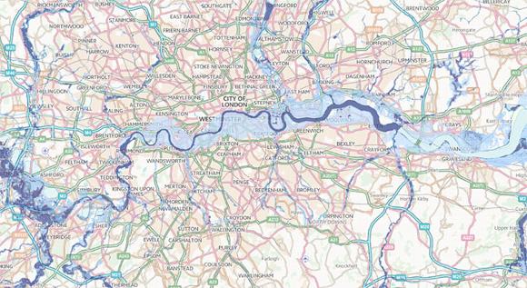
When it comes to flood mapping, the Environment Agency and Natural Resources Wales provide valuable information regarding flooding but typically focuses on major rivers. In addition, there are instances where their existing river models require updates either due to the impact of climate change or where they lack the necessary precision to evaluate flood risks associated with proposed new developments. As a result, conducting river modelling work becomes essential to produce reliable Flood Risk Assessments (FRAs) or Flood Consequence Assessments (FCAs).
River modelling serves various purposes, including:
- Determining the potential for flooding to proposed developments
- Integration within FRAs or FCAs (often incorporating the previous point)
- Environmental Impact Assessments
- Flood Mapping
- Investigation of river flooding issues
- Designing flood alleviation schemes
- Evaluating the consequences of reservoir failure or flood-defence breaches
- Designing structures on or in river channels, such as bridges, culverts, and weirs
2D Flood Modelling
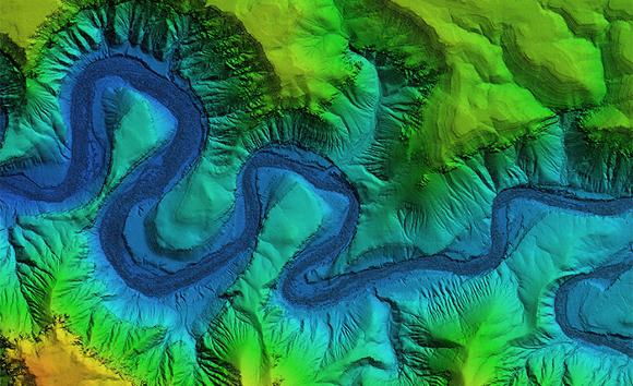
In many situations 2D Flood Modelling can serve as an alternative to 1D River Modelling. Unlike the latter, which requires representing the watercourse channel using cross-sections, 2D Flood Modelling simulates water flow across a representation of the ground surface using x, y, and z coordinates.
For 2D flood modelling, we employ Flood Modeller Pro or TUFLOW software, often in conjunction with LiDAR data. Similar to 1D models, this technique frequently incorporates flow hydrographs derived from FEH hydrological studies.
Comparing 1D and 2D Flood Modelling
2D Flood Modelling excels in representing flows across river flood plains, but it can also simulate flows in river channels. However, the software has limitations in this aspect due to the spacing of the LiDAR data grid. Representing structures within the river channel, such as bridges, weirs, and sluices, may not be fully satisfactory using 2D flood modelling.
Conversely, 1D River Modelling software is particularly suited for simulating structures within river channels. Nonetheless, while 1D models can represent water storage within floodplains, this process can be intricate and time-consuming. In such cases, 2D software is more suitable.
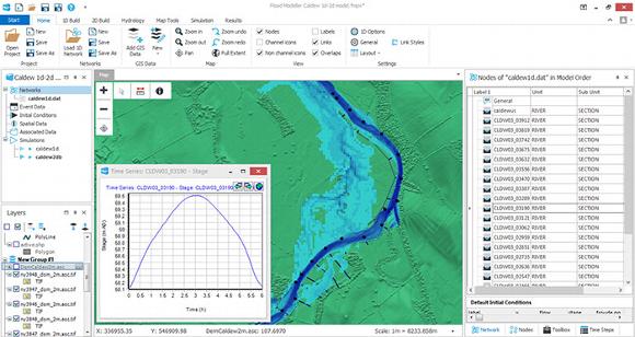
Linked 1D-2D Flood Modelling
Linked 1D-2D flood modelling provides a solution where both programs complement each other's strengths, typically offering the most effective modelling outcome for larger catchments. In this approach, the 1D model represents the river channel, while the 2D model represents the flood plain. Both models work in conjunction with each other, with the 1D model transferring floodwater to the 2D model and vice versa as the storm develops.
arrange a consultation with our team of experts
To arrange a call back from our flood risk consultants, fill in the form here.
Office: 020 805 850 22
Mobile: 079 166 898 93