A comprehensive overview of flood risk on your development
We cover all critical aspects of flood risk management, Sustainable Drainage System design and surface water management. We are one of the UK's leading providers in SuDS design providing a wealth of experience to developers, planners and property owners looking to safeguard their properties for the future.
The importance of Flood Risk Assessments
New developments or changes to the use of a site can reduce the ground's capacity to provide natural drainage, increasing the risk of surface water runoff and flooding. Local authorities and environmental agencies are responsible for ensuring that with the development of new properties, the chances of fluvial or tidal flooding are limited by taking a proactive approach. The main flood risks come from the sea and rivers. However, numerous other sources could pose a flood risk, such as reservoirs, groundwater, surface water sewers and overland flow.
Flume are here to help
Flood Risk Assessments should always be carried out by experienced chartered civil engineers specialising in flood risk. By enlisting the help of a flood risk consultant from the start of the planning application process, you will reduce the cost and time spent in the long run.
Flood Risk Assessment FAQs
What is Fluvial Flooding?
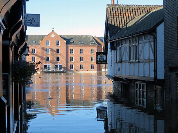
Fluvial flooding, also known as river flooding, refers to the overflow of water from a river, stream, ditch, or watercourse that causes water to inundate the surrounding land. This type of flooding occurs when the water level in a river exceeds the level of the bank, causing the water to flow onto adjacent floodplains. Fluvial flooding can be caused by heavy rain, river channel blockages, high tides, and other factors, and it can result in damage to homes, businesses, and infrastructure.
What is considered a Fluvial Flood?
Fluvial Flooding is a type of flood that occurs when a river overflows its banks and inundates the adjacent land. It is typically caused by heavy or prolonged rainfall. The severity of fluvial flooding is primarily determined by the intensity and duration of rainfall within the river's catchment area. Nevertheless, several other factors can exacerbate flood risk, including soil water saturation, the topography of the surrounding terrain, and the drainage characteristics of the area.
The impact of Climate Change
The risk of fluvial flooding is expected to increase with more intense rainfall due to climate change. However, the flood risk associated with watercourses are not the only sources of flood risk in the UK. Floods can also occur due to surface water, reservoir overflows, groundwater or infrastructure failure. Fluvial flooding can cause significant damage to homes, businesses, infrastructure, and natural habitats, and can pose a serious risk to human life.
What other forms of flooding are there?
The two other main flood types as it relates to Flood Risk Assessments are Pluvial Flooding and Tidal Flooding:
Surface Water (Pluvial) flooding is a type of flooding that occurs when there is an excessive amount of rainfall that cannot be absorbed by the ground, leading to the flooding of the surrounding area. Unlike fluvial flooding, which is caused by overflowing rivers, pluvial flooding is caused by intense rainfall overwhelming the drainage systems in urban areas or watercourses that are usually dry. Pluvial flooding can occur in any location, but it is more common in densely populated areas with high levels of impermeable surfaces such as pavement, roads, and buildings, which can prevent the water from soaking into the ground. With the increasing frequency and intensity of extreme weather events, the risk of pluvial flooding is expected to increase, especially in urban areas.
Tidal flooding, also known as coastal or storm surge flooding, occurs when sea levels rise and water inundates low-lying coastal areas. This type of flooding can be caused by high tides, strong winds, storm surges, and other factors that cause water to accumulate along the coast. With rising sea levels due to climate change, the risk of tidal flooding is expected to increase in many coastal areas around the world. Local authorities and environmental agencies often implement measures to protect against tidal flooding, such as sea walls, flood barriers, and other forms of coastal protection.
What is surface water flooding?
Surface water flooding occurs when rainwater cannot drain away fast enough or soak into the ground, leading to the water gathering on the surface and potentially causing flooding. This can happen when there is heavy or prolonged rainfall, particularly in urban areas with large amounts of impermeable surfaces such as concrete or asphalt, which prevent water from infiltrating into the ground. Surface water flooding happens when the volume of rain can’t be drained by existing drainage systems or absorbed in the ground. As more of the country becomes urban ground covered in concrete and other non-permeable material, the risk of surface flooding increases.
Surface water flooding can also be caused by blocked drains and watercourses, which can prevent water from flowing away properly. This type of flooding can occur anywhere, but is particularly common in low-lying areas and areas with poor drainage infrastructure.
The UK Environment Agency is the government agency responsible for managing the risk of flooding from all sources, including surface water flooding. They work to reduce the risk of flooding through a variety of measures, including maintaining flood defences, improving drainage infrastructure, and providing flood warnings to the public.
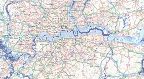
Which Areas Does Surface Water Flooding Effect?
Even if you are looking to develop in Flood Zone 1 (Low Risk of Fluvial Flooding), your property development can still be susceptible to surface level flooding and planning applications may require a Flood Risk Assessment before any work commences. Before any work commences on your site, you must check with your local authority that there are no Critical Drainage Areas on-site. Critical Drainage Areas or CDAs are at high risk during flash floods.
What is a Critical Drainage Area?
A Critical Drainage Area (CDA) is an area of land that is particularly susceptible to flooding or drainage problems due to its characteristics or location. This can include areas that are low-lying, have poor drainage infrastructure, or are located in the path of runoff from upstream areas. In some cases, critical drainage areas may be designated by local authorities or environmental agencies, and special measures may be put in place to mitigate the risk of flooding or drainage problems. These measures can include improved drainage infrastructure, changes to land use patterns, and other strategies to manage storm water runoff. Identifying and managing critical drainage areas is an important part of flood risk management and urban planning, as it can help to reduce the impact of flooding and drainage problems on communities and infrastructure.
Check critical drainage - flood risk issues in your area
To check how much of a risk surface water flooding poses to you and your property, you can view the flood risk maps on the Environment Agency's website and search by your location or postcode.
As climate change continues unabated, the cost of flood damage is projected to surge by approximately 40% to reach £420 million by 2050, primarily due to increased occurrences of heavy rainfall events.
If your site is located in Flood Zone 1 and you are looking to see what you can do to prevent floods, or get a Flood Risk Assessment, contact a member of our flood risk team.
arrange a consultation with our team of experts
To arrange a call back from our flood risk consultants, fill in the form here.
Office: 020 805 850 22
Mobile: 079 166 898 93